
Exhibit & Programs running Sept. 1-29, 2022
Mapping Equity in Dayton, a traveling exhibit developed by a team at Sinclair, will be on display in Wright Library’s Community Room during the month of September.
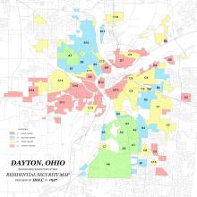
The exhibit uses maps along with current and historical data to show how communities today are still affected by redlining, a 1930s U.S. government practice that ranked neighborhoods and then used color-coded maps to decide who could receive subsidized housing loans and other resources.
“This exhibit brings the power of maps to bear on our understanding of how and why some of our communities have more or less resources and opportunities than others, and to begin conversations about how we view, conceptualize, and respond to racism.” according to Dair Arnold, Director of Sinclair's Center for Teaching and Learning.
About the exhibit
Dr. Jacqueline Housel, Sinclair Professor of Geography. and her team have created the panels as an easily understandable tool for visualizing and examining data about redlining, health, education, green space, and police violence in Dayton and the surrounding area. The Mapping Equity exhibit represents the collaborative and innovative nature of the work Sinclair is doing to recognize the vestiges of redlining.
See the exhibit
The exhibit is open during most library hours. Call ahead to confirm availability.
Private tours for school classes, churches, clubs or other groups available upon request. Contact Jacqueline Housel at Jacqueline.housel@gmail.com to inquire.
Related events
See below for list of events highlighting the exhibit. Wright Library's LET'S TALK series promotes in-depth conversation, intentional community, respect, active listening, and problem-solving among neighbors.